Ghostly Satellite Appearances: Decoding a Starlink Apparition on Google Earth
Introduction
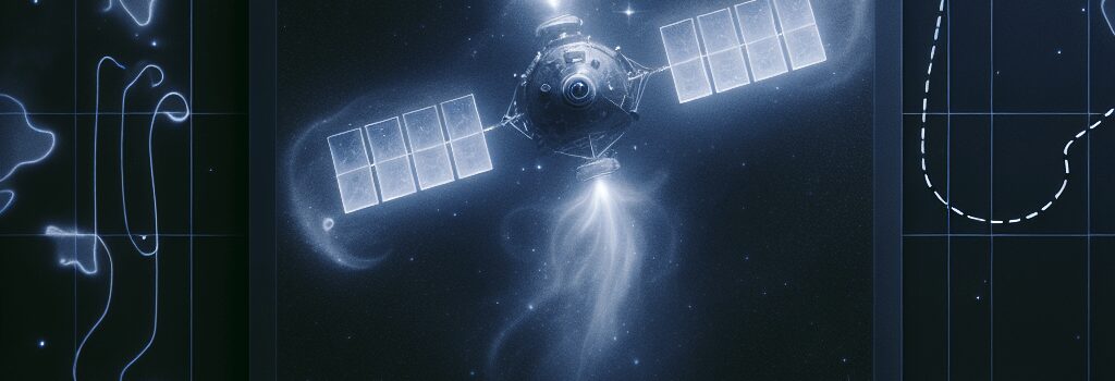
If you’ve ever zoomed in over rural North Texas on Google Earth, you might have been startled by a surreal, multi-colored apparition dancing above wooded bottomlands. This unusual sight, captured on November 30, 2024, is now under scrutiny by space enthusiasts and imaging experts alike. Early analyses suggest the image might depict one of SpaceX’s Starlink satellites – possibly one from the Starlink V2 Mini constellation, recognizable by its dual solar panels spanning roughly 30 meters.
The Science Behind the Imaging
Google Earth’s latest capture was taken by Airbus’ high-resolution Pleiades observation satellite. Unlike typical Earth observation imagery, the Pleiades system is equipped to record in several spectral bands: blue, green, red, panchromatic, and near-infrared. In the composite image, the satellite appears in five different color layers, each corresponding to these spectral captures. The near-infrared band outlines the satellite’s silhouette, while the traditional red, blue, and green bands combine with the high-resolution panchromatic shot to create the intriguing multi-hued effect.
Technical Analysis of the Artifact
What makes the image especially remarkable is the manifestation of imaging artifacts caused by the satellite’s high velocity. Objects in low-Earth orbit travel at speeds exceeding 27,000 km/h (over 17,000 mph), meaning that even a split-second delay between multi-spectral snapshots can lead to multiple appearances of a single object. In our case, the satellite appears as five distinct, colored imprints. This phenomenon underscores the challenges involved in synchronizing images captured over multi-spectral bands and offers valuable insights into the limits of current satellite imaging technology.
Imaging Artifacts and Data Processing Techniques
Such artifacts are not just curiosities but also serve as a window into the complex processes of satellite image stitching and post-processing. Modern Earth observation systems use rapid-fire captures that are later combined using sophisticated algorithms designed to correct for motion and spectral discrepancies. With satellites moving nearly 5 miles per second, even minuscule delays between captures lead to significant spatial offsets. Experts now suggest that refining synchronization techniques using real-time AI algorithms could vastly improve image coherence, especially for rapidly moving targets in LEO (low-Earth orbit).
Operational Environment: Speed and Scale
Comparing a satellite’s rapid transit with other aerial vehicles illustrates the scale of technical challenges involved. For example, while a B-2 stealth bomber (whose image once appeared smeared over Missouri on Google Earth) travels at a fraction of these speeds, satellites must adhere to orbital mechanics that require incredibly precise velocity to avoid re-entry. With over 9,300 active satellites and thousands more pieces of debris orbiting the planet, distinguishing one object from another becomes a herculean task. The sheer volume of objects demands advancements in both sensor resolution and tracking algorithms.
Deep Dive: Future Trends in Satellite Imaging
- Enhanced Image Synchronization: Future satellite systems will integrate AI-driven real-time data processing to better sync multi-spectral captures, reducing artifacts even at extreme velocities.
- Commercial and Military Synergies: As companies repurpose Earth observation cameras for off-Earth imaging, potential applications in both commercial and defense sectors are expanding rapidly. This has sparked discussions on regulatory frameworks and international standards for space imaging.
- High-Resolution Tracking: With initiatives to upgrade sensor resolutions, future systems are expected to capture detailed images of satellites in operation, offering invaluable data for space situational awareness.
Expert Opinions and Broader Implications
Specialists in satellite imaging and space operations agree that this unexpected capture serves as a compelling case study. Dr. Elena Martinez, a leading expert in remote sensing, commented, ‘The artifact observed in the Google Earth capture not only reinforces the challenges presented by high-speed orbital imaging but also highlights the impressive capabilities of modern observation satellites. We are entering an era where commercial satellite imagery will increasingly unveil details about objects in space that were previously unseen.’
Additionally, some Reddit users speculated that an alternative explanation could be a Chinese Earth-imaging spacecraft, such as the Ziyuan 3-02, which was reportedly in the vicinity at the time. Independent verification remains pending, reinforcing the need for more transparent data sharing between nations and organizations regarding satellite movements and imaging captures.
Conclusion
The ghostly appearance of what is likely a SpaceX Starlink satellite on Google Earth stands as both a modern marvel and a reminder of the technical challenges that come with imaging objects moving tens of thousands of miles per hour. As imaging technology continues to evolve, we can expect not only clearer views but also more in-depth analyses of the orbital environment around our planet. This convergence of high-speed imaging, advanced data processing, and global satellite networks will undoubtedly open new chapters in both scientific research and practical applications worldwide.